The area surrounding
St Philippe often gets neglected as a
hiking destination in favour of
Réunion's more challenging sites. This is a shame as trekking in this low-lying part of the island at the foot of
Piton de la Fournaise can offer a different perspective of the island.
 |
| near the 2007 eruption |
We got dropped off by our transport close to the site of the
April 2007 eruption, and from there we walked along the quiet main road until we came to the turn-off for 'Le Vieux Port'.
 |
| wild vanilla |
From here we walked along a track until we reached the coast. St Philippe is prime
vanilla-growing area, and a lot grows here wild (there are no pods though, as the vanilla needs to be hand-fertilised to produce any).
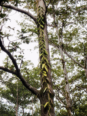 |
| wild vanilla growing on a tree-trunk |
 |
| vanilla flower |
 |
| 'The Old Port' |
 |
| beach area, Le Vieux Port |
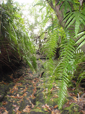
We then headed west, walking along the coastal path (Sentier Littoral de St Philippe).
 |
| coastal path, St Philippe |
Although St Philippe is not at a high altitude its location on the extreme south-east coast means it gets plenty of rain, and so plant life is luxuriant.
 |
| wild orchids |
 |
| more wild orchids |
 |
| close-up of wild vanilla |
The most common tree here is the screwpine (
Pandanus utilis), known locally as the
vacoa.
The name screwpine comes from the spiral arrangement of the leaves around the branches.
 |
| prop root system of vacoa tree |
Vacoas have an unusual root system whereby prop roots grow from the stem well above soil level; these roots help to anchor the plant and keep it upright during periods of heavy wind and rain.
 |
| young prop root |
The young roots have a rather phallic appearance, reinforced by the fact that the root tip is covered by a removable cap!
 |
| removable cap on young Vacoa prop root |
Vacoas grow well near the sea as they are salt-tolerant. (Another variety,
Pandanus montanus, grows in the highlands of Réunion).
 |
| interesting root growth |
The leaves are long and spiny and make a thick covering when they fall to the ground. They are used for thatching and to make ropes, baskets, mats, hats, placemats, and bags.
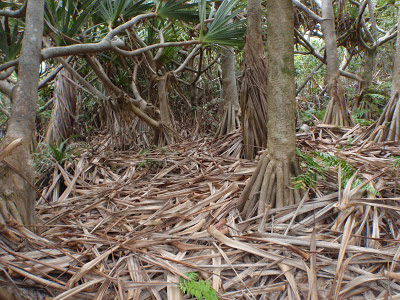 |
| a forest floor 'carpet' of Vacoa leaves |
The fruit is called a pinpin and can be cooked and eaten. This, together with the tree's leaves and erosion prevention properties, make it a very useful plant to have around.
 |
| pinpin, screwpine fruit |
 |
| close-up of a pinpin segment |
After a while, we started to get a clearer view of the coast, which had never been very far, but whose view had often been obscured by vegetation.
 |
| fishing |
We soon came across signs of the 1986 volcanic eruption, which is one of only six recorded eruptions to have taken place outside the main
caldera.
 |
| The 1986 eruption took place from March 20-29 |
 |
| Mother nature always finds a way to grow back after an eruption! |
 |
| open-ended lava tunnel |
At the time, in 1986, the lava flows enlarged the island by 25 hectares at a place known as La Pointe de la Table, pushing the coast 200 metres out into the sea along a distance of 1.5 km. Since then the sea has battered away at this 'intrusion', and today not much of it is left.
 |
| Pointe de la Table |
In 1776 an eruption whose lava flows were particularly thick took place. As it slowly cooled the
basalt fractured into prismatic shapes which some liken to organ pipe columns.
 |
| basalt column cliff, Pointe de la Table |
 |
| coastline |
 |
sprouting Fish Poison Tree, known as Bonnet
d'Evêque in Réunion (literally 'Bishop's Hat') |
After hiking for about 12 km we eventually reached a picnic area, where we had lunch before walking a short distance to the main road where our transport was waiting for us.
 |
| toadstools |
By the way one of St Philippe's claims to fame is that it is the starting point of the annual
Diagonale des Fous aka
Grand Raid ultra-marathon mountain race. (You can see a video about the race
here).
The people of St Philippe enjoy gardening, and walking past their gardens to the main road was a real pleasure, as you can see from these photos.
Useful map:
Piton de la Fournaise (La Reunion)
IGN 1:25,000 topographic map 4406 RT
If you liked this, you might like:


No comments:
Post a Comment