
L'ile aux parfums is France's newest
département since March 2011. We first visited
Mayotte in 1995, almost eighteen years ago, and decided it was time for a new trip - in particular we wanted to
scuba dive in the lagoon, one of the world's largest
.
|
|
| Location of Mayotte, in the Mozambique Channel (Source: Wikipedia) |
|
|
| Map of the island of Mayotte (source: Wikipedia) |
Mayotte consists of the larger Grande Terre and the tiny Petite Terre, on which the
airport is located (more about Petite Terre later). Regular passenger and car ferry barges ply the 2 km separating the two islands. Mayotte is sometimes referred to as the
Ile Hippocampe as the island's shape resembles a seahorse.
 |
Looking over part of Mamoudzou to Mbouzi islet, a former
nature reserve; ylang-ylang tree in the foreground (right). |
Mayotte and the Comoros are known as the Perfumed Isle(s) due to their culture of
ylang-ylang, a flower highly valued for its perfume. (The fragrance seemed less omni-present than on my previous trip however, possibly due to the fact that cultivation and exports are decreasing as they become less competitive).
 |
| view of Mamoudzou's marina |
Even in Mamoudzou the
mangrove is never very far away.
 |
| mangrove near Mamoudzou |
Like Réunion, Mayotte has no dangerous wildlife on land except
scolopendra centipedes, which are much more common on Mayotte than Réunion. They can give an extremely painful bite.
 |
| the only scolopendra we saw, thank goodness! |
After our stay in Mamoudzou we hired a car and headed to
Bouéni in the island's south-west, stopping off at various points along the way.
 |
| M'taspéré mosque |
The south is where you'll find most of the island's
baobab trees, the largest specimen of which is at Musical Plage,
Bandrélé, with a circumference of more than 28 metres.
 |
| Baobab tree, Musical plage, said to be 600 years old. |
Baobabs are amazing trees which can live for up to 2000 years. They can be a source of medicine, food, water, dye, fibre and fuel.
 |
| Baobab fruit |
There are two species present in Mayotte : Adansonia digitata and Andansonia madagascariensis.
 |
Baobab juice (left), made from baobab fruit
(THB beer from Madagascar) |
 |
| Baobab jam (jelly) |
 |
| child, Musical plage |
Mayotte is surrounded by about thirty islets, most of which are uninhabited.
 |
| Ilot Bandrélé, Mayotte's 5th largest islet |
 |
| Sakouli beach |
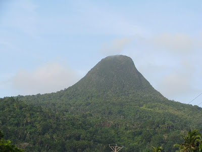
The hand-shaped southern part of Grande Terre is dominated by
Mount Choungui, 594m.
 |
| Mount Choungui |
We spent four nights in Bouéni, which is located on a peninsula.
 |
| Bouéni |
While Mamoudzou, like all of Mayotte, has its fair share of wildlife, away from the largest town flora and fauna were even richer.
We saw a great variety of crabs, including one like this in our bathroom:
 |
| bathroom crab! |
 |
| mangrove crab? |
 |
| small beach crab |
 |
| hermit crab |
But Mayotte is most well-known for two of its mammal inhabitants:
flying foxes (fruit bats) and brown
lemurs (
makis).
 |
| Flying foxes are known as roussettes in French |
Makis are the only animals to cover their dead (with leaves/earth), and one of the few primates to possess finger prints.
 |
| Common brown lemurs are known as maki on Mayotte |
 |
| a turtle made by children, but we saw plenty of real ones diving! |
 |
| N'gouja beach, where you can swim with turtles |
Next it was time to head up the west coast for the third and final part of
our diving trip.
 |
| scenic Bouéni bay |
 |
| the town of Sada is located halfway up the west coast |
 |
| Sada islet |
When leaving
Sada we had the (rare?) chance to see a
waterspout out in the ocean.
 |
| waterspout near Sada |
In the north-west we stayed at Ambato, near
M'tsangamouji, and
went diving at
M'liha. Touristically, this is a rather undeveloped part of the island where accommodation and eating places are hard to come by (although Mayotte as a whole is not highly developed for visitors).
 |
| boys playing, M'tsangadoua |
 |
| boys playing, M'tsangadoua |
 |
| house, M'tsangadoua |
A cheap meal that's always easy to find however is brochetti - skewers of meat, served here with fried green bananas.
 |
| brochetti, fried green bananas and chilli sauce |
 |
| an example of traditional architecture, using wood & earth |
From this part of the island you can sometimes see the neighbouring island of
Anjouan, about 80 km away. Mayotte suffers with a major illegal immigration problem from the other Comorian islands (mostly Anjouan), with unwieldy small boats (called
kwassa-kwassa) regularly making or trying to make the crossing to the French island. Some locals refer to this stretch of water as the 'world's biggest cemetery'.
 |
| Anjouan |
The final leg of our trip saw us heading along the north coast to take the barge to Petite Terre for our last day and night in Mayotte.
 |
| Mtsamboro islet (left) and the Choazil islets (right) |
 |
| Handréma peninsula, extreme north-west of Mayotte |
 |
| Mtsongoma islet, with beacon |
Petite Terre's most striking site is Dziani (dziani actually means lake in Mahoran), an emerald-green crater lake which you can walk round. Formed 500 0000 years ago it's a reminder of Mayotte's volcanic past.
 |
| Dziani lake, Petite Terre |
 |
| view from Dziani across northern Mayotte |
 |
| view from Dziani across to Mamoudzou |
 |
| one of the twin beaches of Moya, Petite Terre |
The Christian cemetery at Sandavangeu holds the tomb of Henry de Balzac,
Honoré's younger brother.
The small part of Petite Terre known as Le Rocher is linked to the larger part by a road called the Boulevard des Crabes built on a dyke. It holds several XIXth century colonial buildings from which the French administrators governed their Indian Ocean possessions. The former Governor's Residence was built in 1881 based on plans drawn by
Gustave Eiffel.
 |
| the former Governor's Residence, later the Prefecture |
Some facts about Mayotte:
- Area: 374 km2 (16 km2 for Petite Terre and 354 km2 for Grande Terre and the islets)
- Coastline: 185.2 km
- Highest point: Mount Bénara, 660m
- Population: officially 231 139 inhabitants in 2010 (2000 on Petite Terre); figure doesn't include illegal immigrants
- Official language is French but is only spoken by 35% of the population; shimaore and kibushi are more widely spoken.
- Religion: 95% muslim (Shafi'i sunnite), 4% catholic, 1% protestant
 |
| cannon, former Governor's Residence |
Useful links:
 |
| baby palm tree |
Related posts:
Further reading:


No comments:
Post a Comment