The full title of this book by William Dudley Oliver (WDO) is "
Crags And Craters: Rambles In The Island Of Reunion". Originally published by Longmans, Green, and Co. in 1896 it has been republished by Bibliolife as an exact reproduction (i.e. it's not an OCRed copy). However Bibliolife made an error with the title and called it "RambleRs in the island of Reunion".
 |
| view near Cilaos |
The author spent six months in
Reunion from July 1895 to January 1896. We never find out much about the writer or why he came to Réunion, although it would seem he knew previously the then
British Consul on Reunion, Courtenay Walter Bennett. According to
this link Bennett had been named Consul to Reunion in 1890. A British Consul on Reunion at that time would have had quite a lot of work as there were many indentured Indian labourers on the island, and as
India belonged to Britain at the time, they fell under his jurisdiction.
Coming back to the author, as a 19th century white and (presumably) upper class male he came to the island with a baggage of colonial beliefs and prejudices rather typical of his upbringing, and this should be borne in mind while reading the book. However despite this, on the whole he is generally fair and decent in his written treatment of the island's inhabitants.
 |
Gros Morne
|
While on the island and not hiking he seems to have spent much of his time in
Hellbourg at the Châlet Consulat due to the heat on the coast. "It is an absolute necessity for Europeans dwelling in a tropical climate to have some place to which they can go to recruit their exhausted energies"(page 46).
Possessed with a lot of energy and/or curiosity he hires a guide and some porters (who all walk barefoot!), and over the course of six months manages to visit most of Réunion's summits: the
volcano,
Piton des Neiges, the Salazes etc. When unable to reach a peak first time, he returns to try again! The only mountain that he didn't manage to conquer was the
Gros Morne, unsurprisingly (it was only ascended for the first time in 1939).
 |
| map of Reunion from the book |
For anybody who knows Reunion many of the place names he mentions will be very familiar : Cap Anglais, Belouve, Coteau Maigre, Cap Noir, etc. etc. However some things which have disappeared today are striking to the modern-day reader: for example WDO often uses the railway, and he makes a trip to the village of
Mafate (in the
eponymous cirque) which disappeared in 1913.
 |
The Piton des Neiges
|
I'll leave the last word to the author, who was on his way to the cirque of
Salazie: "... I felt that this drive alone was worth the voyage to Reunion. And yet, grand as it is, it is but a foretaste of the glories awaiting in this wonderful island." Sentiments with which a modern day visitor to Reunion might well agree.
Footnote 1:
On pages 25-26 of the book WD Oliver mentions "an obelisk built of native stone and mounted on a pedestal" which had been "erected to the memory of the English who fell at the taking of the island in 1810." He includes a photo of the obelisk set on the (then) visibly grassy Plaine de la Redoute.
Curious, I went to see the monument as it today. It is now part of a small park and stands not far from the (much larger) French monument to those who fell at the same battle.
Two sides of the pedestal are blank, on one side is the following inscription:
"Sacred to the memory of
Lieutenant John Graham Munro
of his Britannic Majesty's 86th Grenadiers
who fell near this spot
while charging the Enemy
on the 8th July 1810
Aged 22 years
This tomb is erected by his Brother Officers
in testimony of their Esteem and Regard."
 |
| inscription to the memory of Lt. Munro |
On the other side is the following inscription:
"Near this spot
Are also interred
the remains of those Brave Soldiers
of his Majesty's
Eighty Sixth Regiment
who likewise fell
on the same glorious occsion"
 |
| inscription to the memory of the other "brave soldiers" |
As you can see "occasion" is missing an 'a' in the original. Talking of omissions, in a footnote on the subject of the monuments the author says "there is a story that a certain Governor of Réunion, in a copy of the inscription which he made, carefully omitted the word 'glorious' - an instance of small-mindedness which it would be difficult to beat".
 |
| The French obelisk, erected in 1857 |
During the battle 7-9 July 1810 exact numbers of French losses are unknown, but the British lost 22 men and 79 were wounded.
 |
inscription on French monument
|
Footnote 2:
On pages 159-161 the author says:
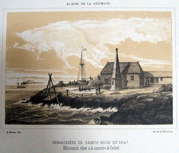
Before breakfast I walked down to the little quay [of Sainte Rose] to take a photograph of the monument erected there to the memory of Captain Robert Corbett, who was killed in action off here on September 13th 1810 while in command of the Africaine. The monument consists of an obelisk close to the shore, and, with the exception of an anchor in relief, is without ornament. There is no inscription.
 |
| An 1847 engraving of the port of Sainte Rose, showing the monument |
Here are some modern-day photos of the statue at
Sainte Rose:
 |
| Corbett monument, Sainte Rose |
The anchor in relief referred to is found on two sides of the obelisk.
 |
| another view of the monument, showing one of the anchors |
Near the monument is a plaque, unveiled by Ste Rose's mayor on 23rd August 2009 to mark the 200th anniversary of a slightly earlier battle, and which reads:
Place du Commandant Hubert Delisle.
Historical site of the 23rd August 1809 naval battle between the French and the British.
 |
| Commemorative plaque |
 |
| one of three nearby cannons |
Further reading:
See also
this video which shows the marina and statue at Ste Rose.
You might also enjoy: