Sunday 13 October 2019

Tevelave, Les Avirons

Here are a few photos from a guided visit to Tévelave we did yesterday. Tévelave is a village located at an elevation of 900 metres in the municipality of Les Avirons on the south-west coast of Reunion. It has a population of 1500, and is about a 10-kilometre drive up from the town of Les Avirons.

meeting point with our guide

The name Tévelave comes from two Malagasy words tévy and lava meaning "big forest". It was originally a place where slaves (some of whom would have been of Malagasy origin) escaped to.

our guide had prepared a snack for us before we set off exploring 

Modern settlement of Tévelave began in the late 19th and early 20th century when smallholders settled there, cultivating subsistence crops and geranium essential oil. Our guide started the walk by showing us several endemic trees, including the critically endangered Tan rouge (Weinmania tinctoria). This tree can grow up to 18 metres high, and the bees who visit it produce a green-tinged honey called miel vert.

Weinmania tinctoria aka Tan rouge

bois rouge tree

trunk of a Calophyllum tacamahaca tree
The village has a small museum with traditional objects and utensils, including a "chabouc" which is a type of whip that was used on slaves and animals (as well as on children by some parents!). It was traditionally made of plaited agave leaves (see my reference to chabouc in my blog post about Madeleine's Children).

a chabouc suspended on some dried bamboo stalks 

this hillock overlooking the village is known as Piton Soutien Gorges,
which literally means "Bra Peak"!

an unusual house in the village called Maison Deveaux

a Yesterday, today and tomorrow bush (Brunfelsia uniflora) aka Franciscea

Tévlave village church 

Avirons means "oars" in French, and the municipality's coat of arms shows a pair of crossed oars and two Reunion ibis birds. These oars might have been stuck into the ground as some sort of sign, although it's also been suggested that "Les Avirons" is a transformation of the Malagasy word zavironne meaning "a place that can be seen from afar".  The town of Les Avirons was first settled in 1718 by coffee growers. Sugar later replaced coffee and by 1836 14,500 hectares were covered in sugar cane. By 1848 the figure was 23,000 hectares. Although it was initially part of the municipality of Saint-Louis, Les Avirons became a municipality in its own right in 1894.

Coat of arms of Les Avirons 

an azalea tree in a garden

looking across the village to the sea

overgrown shack

After the guided visit we had an excellent meal before heading back down to the coast.

If you'd like to do this visit, either on foot or by bike, (or need a professional guide for other visits to Reunion) you can contact our guide Mathieu Pitou via his website or Facebook page. He speaks fluent English and Italian.

P.S. In my post Did you know? Some facts about Reunion I mention that a raspy cricket on Reunion was found acting as a plant pollinator for the first time in the world (see here for more information about that). The plant pollinated is Angraecum cadetii, a species of orchid endemic to Reunion, and the botanical name cadetii comes from one of Tévelave's most famous former inhabitants, the botanist Theresien Cadet.


See also:


Sunday 6 October 2019

Villa Rivière

For European Heritage Days 2019 one of several buildings I visited was Villa Riviere in the town centre of Saint-Paul, on Reunion's west coast. Unlike other buildings that are only open for EHD and are free, Villa Riviere is actually open at other times of the year and there is a fee to visit it, whether or not it's EHD. The entrance charge is well worth it though, as this is one of the most beautiful Creole villas I've ever seen.

front of Villa Rivière 

It was built in the late 18th century in a neoclassical style using stone (basalt) for the building itself and wood for the facade.  The two-storey villa, outbuildings, and garden have been listed as a Historic Monument since 13th March 1990, but have  always remained in private hands.  The house opened to the public for the first time in 2008.

side view of the house front (photo from website)

You are free to visit and take photos of the garden and original kitchen (which is located behind in an outbuilding), but to visit the interior you have to take a tour with a guide and cannot take photos inside the house.

swimming pool

kapok pods, from a kapok tree in the villa garden

kumquats in garden, Villa Riviere 

detail, front verandah 

top floor back verandah 

planter's chair, top floor back verandah 

The house owners are also interested in the arts, and every year since 2014 have organised the "Villa Riviere Prize" which rewards an artist whose work is directly related to the tangible or intangible heritage of Reunion Island. The artwork below is not by one of the prize winners, but simply reflects the owners' interest in contemporary art.

wall artwork, Villa Riviere 

ground floor back veranda, Villa Riviere 

wood flooring, interior (photo from website)

wall covering, interior (photo from website)

At the time of writing this blog post the Villa website is not very well translated into English, but you can nevertheless glean the essential information from it about prices, as well as opening days and times.

Sunday 25 August 2019

Forêt de Sainte Marguerite

The Forêt de Sainte Marguerite is a forest on the east coast of Reunion, in a highland area of Saint-Benoit known as Saint-François. 

view of the coast from Forêt de Sainte Marguerite

It's located at an elevation of 650 metres and part of it falls within the National Park of Reunion

the green spot show the location of Foret de Sainte-Marguerite 

It's roughly 700 metres wide and 2 kilometres long and to the north is limited by Ravine Saint-François, while to the south it's bordered by Ravine Sainte-Marguerite.


It's considered a 'fragile natural area' in terms of its diversity of plant species, and was created in the late 1970s and mid-80s when Reunion's Departmental Council bought three pieces of land to protect and restore the  unique fauna and flora. 


Today it's managed by the Departmental Council and the APMNEST (an association that protects natural environments in the east of Reunion).


There are over 150 indigenous species of plants as well as lots of Pandanus montanus screwpines and tree ferns.


A nature trail exists, but is no longer very well maintained. There are however several picnic tables, including one with a roof.


The forest is surrounded by agricultural land, including sugar cane, and fields of bananas and pineapple.

field of pineapples 


See also:


Sunday 11 August 2019

Toronto & Niagara Falls

For our month-long trip to Michigan we flew in and out of Toronto as the airfare was significantly cheaper. So at the start and end of our journey we spent two and three nights respectively in Toronto.  (This was our second trip to Canada, although on the previous occasion in 2003 we'd only been to Quebec). At the start of this trip we were with my brother and his car, and as my husband and I knew we'd be coming back to Toronto by ourselves later we wanted to make the most of having transport. So on our first day we headed north out of Toronto to Georgian Bay, 'bay' being somewhat of a misnomer as this body of water located in north-east Lake Huron is almost as large as another Great Lake, Lake Ontario!

view over part of Georgian Bay and Parry Sound
from a former forest fire outlook tower

Georgian Bay has more than 1,240 miles of granite shoreline and is part of a UNESCO biosphere reserve. Its 30,000 islands make it the world's largest freshwater archipelago and seaplanes are a useful means of transport in the area.

former forest fire outlook tower at Parry Sound 

seaplane at Parry Sound

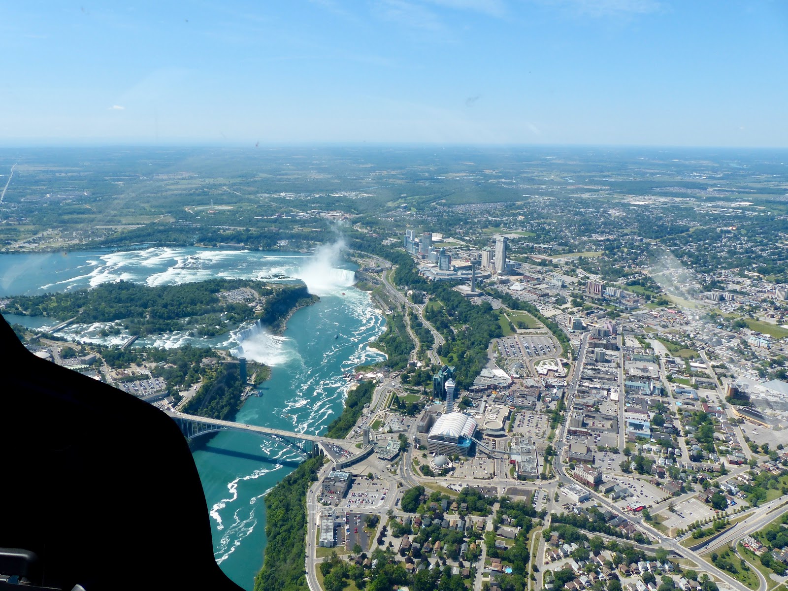
The following day it was time to head to one of the highlights of our trip, Niagara Falls. Rather than doing a boat trip to the foot of the falls we preferred to fly over them on a short helicopter ride.

our Niagara Falls helicopter 

Niagara Falls from the helicopter, Canadian side to the right

Niagara Falls from the helicopter, Canadian side to the right

Niagara Falls from the helicopter, Canadian side to the left

Niagara Falls from the helicopter, Canadian side to the left

Niagara Falls from the helicopter, Canadian side to the bottom and right

After that we headed to see the falls up close. My brother, who's been to Niagara about 7 or 8 times, said that the plume of spray rising up was one of the highest he'd ever seen.

plume of spray, Niagara Falls 


'Maid of the Mist' boat at the foot of the falls 
looking across to the American side

After admiring the Falls we had lunch at the town of Niagara-on-the-Lake, before heading to Detroit, a 4- to 5-hour drive away. We were back just over three weeks later, having been dropped off at Windsor (a Canadian town on the south bank of the Detroit river directly opposite Detroit) and then taken the train from there. During the 4-hour ride the train stopped at London (of course when you're in Windsor you're never very far from London)!

London, Ontario train station sign

Once back in Toronto we stayed in East Chinatown, which reminded us of our time spent living in Asia.

in Toronto we stayed in East Chinatown, very reminiscent of Asia

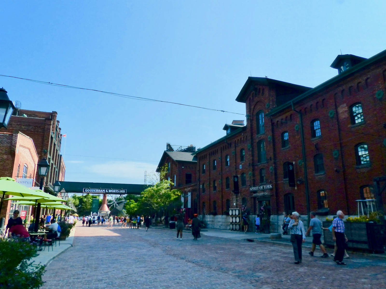
We had some time on our first day to get to grips with the (very efficient) Toronto public transport system and visited the Distillery District, a 5-hectare pedestrian only area that was once the world's largest distillery. Its 150-year-old cobblestone streets are now full of restaurants, cafés, bars, galleries, art studios, performance venues and speciality shops.

Distillery District, Detroit 

The next day we headed to the city centre.

Toronto sign at Nathan Philips Square

old City Hall seen from Nathan Philips Square

The old City Hall building was completed in 1899 and now serves as a courthouse since the new City Hall was built in 1960s.

old city hall seen from the front

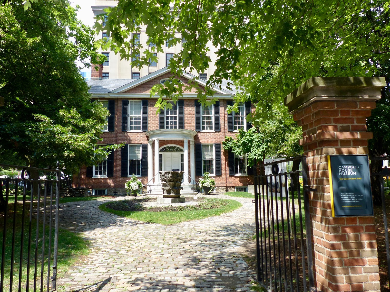
 Campbell House dates from 1822 and is the oldest remaining building in the city.

Campbell House is a Georgian building

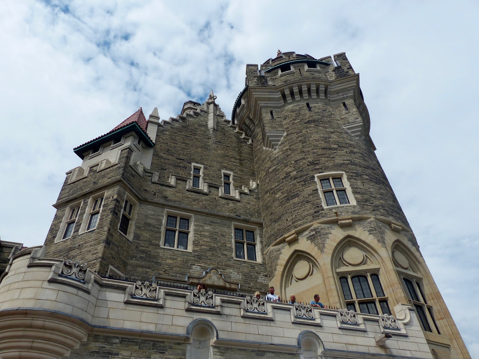
In the afternoon we went to Casa Loma, an Edwardian-style mansion completed in 1914 for a prominent financier and industrialist of the time, Sir Henry Pellatt.

Casa Loma

Unfortunately financial ruin meant that he was forced to leave his 98-room home less than years after is was built.

the 'Scottish Tower', Casa Loma

view of downtown Toronto from the 'Scottish Tower', Casa Loma 

this fully-functioning basement wine cellar holds over 1500 bottles 

After walking through an 800-ft underground tunnel that connects the house to the former stables you reach the small Automotive Museum, which has a collection of early twentieth-century cars. Interestingly the tunnel features an exhibit called 'Toronto’s Dark Side', which tells the story – using archival photographs – of darker days such as Prohibition, The Depression, The Plague, The Great Toronto Fire, and Toronto’s first plane crash.

vintage car in Casa Loma's Automotive Museum 

The next day we didn't do much sight-seeing as we had lunch with a colleague, but nevertheless visited the University District and Kensington Market. The latter is more of a district than an enclosed market, with food shops and secondhand clothes shops. It used to be a Jewish enclave, but now many vendors are West Indian, Portuguese or from elsewhere. Incidentally Toronto is a very cosmopolitan city with 51% of its population having been born outside of Canada (compared with 22% for the country as a whole).

Kensington Market 

spiderman visiting Kensington Market 

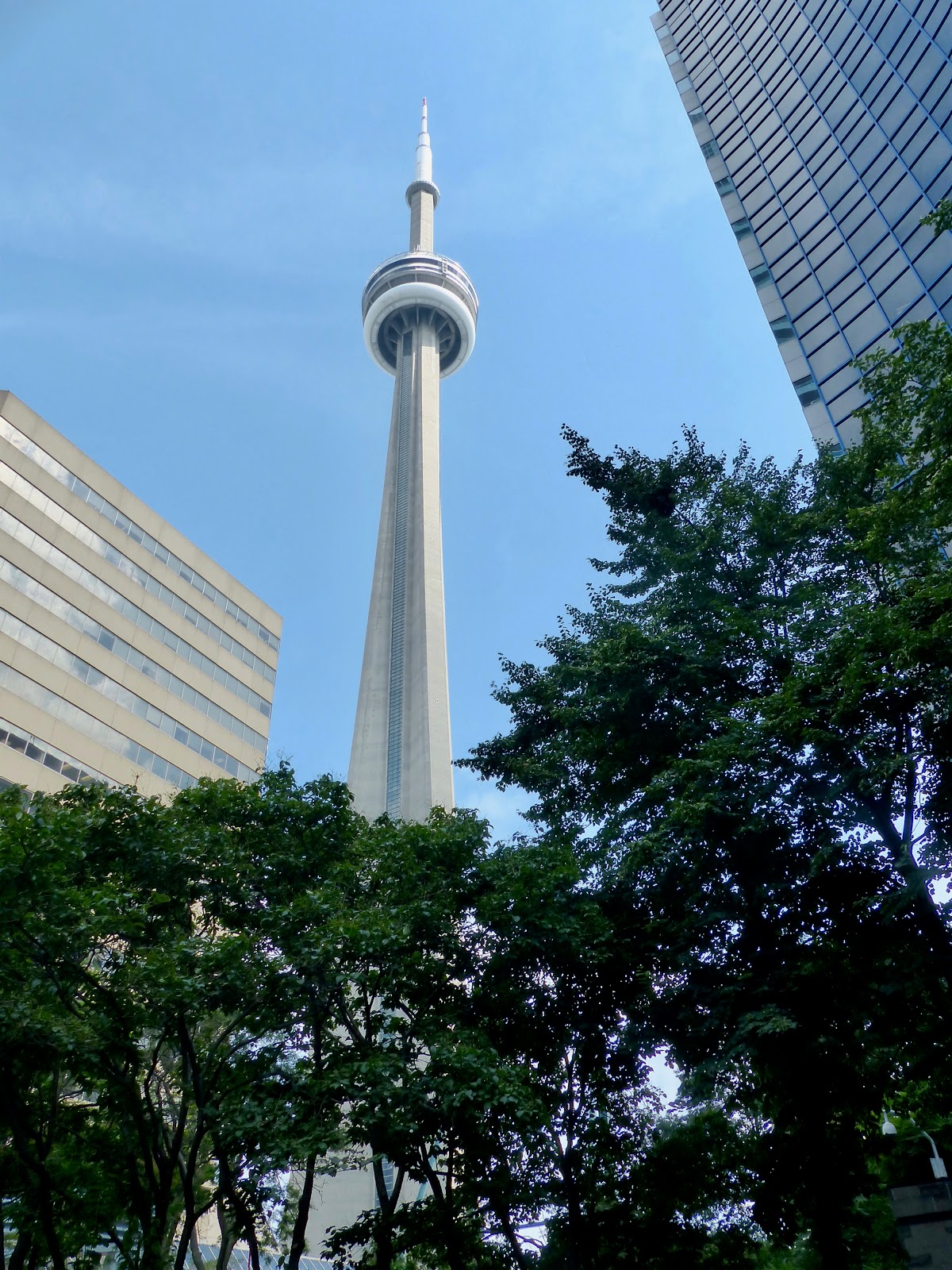
We didn't go up Toronto's iconic CN Tower, but admired it from the ground. The tower has 181 storeys and is 553 metres high. It was built in 1976 by the Canadian National Railway and until 2009 was the world's tallest tower and remains the tallest free-standing structure on land in the Western Hemisphere.

CN Tower, Toronto

As our departing flight was only in the evening we had all of our final day to make the most of, and we chose to visit Toronto Islands. These are a chain of 15 small islands and islets that separate the city's Inner Harbour from the rest of Lake Ontario. To reach them you can take a quick ferry ride (10 minutes) to Ward's Island or Centre Island.

view of Toronto from the ferry to Toronto Islands

view of Toronto from the ferry to Toronto Islands

view of Toronto from the ferry to Toronto Islands

Service vehicles are the only cars allowed on the island and biking is a popular way of getting around, although we chose to walk. We particularly enjoyed strolling along the 2.5 km boardwalk from Ward's Island to Centre Island. 

view of Toronto from Centre Island

On a final note, there were a lot of murals where we were staying in East Chinatown. One of them was of the Mexican archaeological site Chichen Itza, reminding us of our trip there in January just a few months previously!

Chichen Itza mural in East Chinatown, Toronto


See also: