For this, my third trip to Madagascar, we headed to the island's west coast and the Tsingy de Bemaraha, a nature reserve located in the Melaky Region. The area was listed as a UNESCO World Heritage Site in 1990 due to its unique geography, preserved mangrove forests, and wild bird and lemur populations. It has only been open to the public since 1998.
Please note that as our camera was broken during this trip unless other mentioned all photos below are by Vincent Grafhorst, a wildlife photographer we met who was travelling in the same places at the same as us. Please visit his website at: wildscenics.photoshelter.com.
 |
| Spiny chameleon (furcifer verrucosus) |
To get to the Tsingy we first had to fly to Antananarivo (Madagascar's capital) from Reunion, then take a domestic flight to the west coast town of Morondava. There we met our 4WD driver, and were ready for the 8-hour dirt track journey to the Tsingy (no A/C in the car!).
 |
| male panther chameleon |
We stopped 45 minutes north of Morondava at the Avenue of the Baobabs, an impressive alley of huge baobab trees (Adansonia grandidieri), which includes trees that are over 800 years old and reach a height of more than 30 metres.
 |
| Avenue of the Baobabs |
 |
| Avenue of the Baobabs |
Of eight species of baobabs that exist, six are native to Madagascar.
 |
| Zebu cattle under a baobab |
 |
| Girls trading water lilies for sweets |
Baobabs are sometimes called 'upside down trees' as it can look as if they have their roots in the air.
 |
| Avenue of the Baobabs at sunset |
 |
| Avenue of the Baobabs at sunset |
After 200km of dusty driving we finally arrived at the Manambolo River, whose canyon forms the southern boundary of the Tsingy Nature Reserve.
 |
| Ferry loaded with a truck crossing the Manambolo river at dusk |
 |
| Manambolo river gorge |
On a boat trip down the river the following day we saw ancient burial tombs along the gorge banks. You must avoid pointing at them as wherever you are in the park pointing with the finger is a serious fady (taboo).
 |
| rock face, Manambolo river gorge |
On the other side of the river is Bekopaka, the nearest village to the Tsingy and a base for accommodation.
 |
| two young girls doing each other's hair |
The western region of Madagascar is mainly peopled by the Sakalava, one of 18 ethnic groups of Madagascar.
 |
| Bekopaka at dawn |
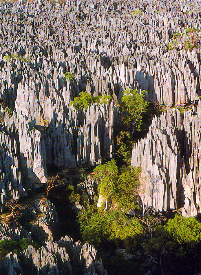
The Tsingy were created when the limestone seabed rose to create a plateau around 200 million years ago, which was little by little eroded by heavy rainfalls and wind over the centuries until it became its actual shape. The result is a maze of jagged razor-sharp limestone pinnacles often towering several hundred metres in the air.
 |
| View of the Tsingy rock formations |
On our first day in the area we started by visiting the 'Little Tsingy' (Petits Tsingy) which are surrounded by a dry deciduous forest, particularly well adapted to the extreme changing climate conditions of the area, and then in the afternoon we took the boat trip along the Manambolo which I've mentioned above.
 |
| Little Tsingy, with the forest behind |
On our second day we visited the main 'Great Tsingy' (Grand Tsingy) area. You visit them using walkways, bridges, ropes and climbing equipment.
 |
| View of Tsingy at dawn |
The word tsingy is Malagasy for "where one cannot walk barefoot" or "walking on tiptoes".
 |
| another view of the Tsingy (source) |
The Tsingy once gave shelter to the Vazimba, the first inhabitants of Madagascar. Legend has it that some Vazimba still live in the Tsingy...
 |
| a path through the rock formations |
The UNESCO World Heritage site is formed of the National Park (666 square kilometres) and the adjacent Strict Nature Reserve (853 square kilometres). Tourists are not allowed to enter the latter.
 |
| bridging the gap - a tourist crossing a suspension bridge in the Tsingy |
The park is also home to over 100 species of birds, eight species of reptiles, and 11 species of lemurs, including Von der Decken’s sifaka.
 |
| Madagascar scops owl |
You should know that the Park is only opened during the dry season from April to November, since it is inaccessible during the rainy season (mid-end November to mid-end May). The Great Tsingy are only accessible between May/June and the beginning of November.
 |
| Monarch butterfly on grass |
After our time spent exploring the Tsingy we headed back to Morandava, spending a night halfway in the town of Belon'i-Tsiribihina, then another night at Kirindy Forest Reserve, a private park about 40-50 km northeast of Morandava.
 |
| Belon'i Tsiribihina (source) |
About 100 square kilometres in area, Kirindy has the greatest density and diversity of primates in the world.
 |
| Red-tailed sportive lemur clinging to a tree |
A number of species of nocturnal lemurs are present there: Red-tailed sportive lemur, Pygmy mouse lemur, Gray mouse lemur, Pale Fork-marked Lemur, Coquerel's Giant Mouse Lemur and the Fat-tailed dwarf lemur.
 |
| Golden silk orb-weaver spider in web |
Fossa, Narrow-striped mongoose, Verreaux's Sifaka, Common tenrec, Greater hedgehog tenrec and Red-fronted Brown Lemur are also found there.
 |
| Red-fronted brown lemurs |
 |
| Verreaux's Sifaka lemur |
 |
| Red-tailed sportive lemur |
One of my most memorable experiences was during the night we spent at Kirindy, when we were woken by the sound of the claws of a fossa walking across the wooden terrace of our cabin!
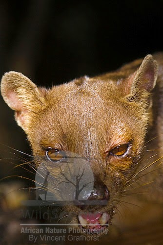 |
| Fossa |
Our next trip was three months later when we headed to South Korea for the start of a three-year stay there.
If you enjoyed this post you might also like:
- Ile Sainte Marie - in 2004 we spent a week on this island off the north-east coast of Madagascar.
- Stone Forest - in November 2009 National Geographic magazine published an article about the Tsingy.
- For more pictures of baobabs and lemurs see this post about Mayotte.
Useful links:
- Kirindy Forest (in French)
- Tsingy de Bemaraha on Lonely Planet
- Tsingy de Bemaraha National park on TravelMadagascar.org
- Tsingy de Bemaraha National Park on Wikipedia
- Tsingy de Bemaraha Strict Nature Reserve on Wikipedia
- Tsingy de Bemaraha Strict Nature Reserve - UNESCO. Tsingy de Bemaraha was the first UNESCO World Heritage Site in Madagascar.
- Wild Scenics African Nature Photography - website of photographer Vincent Grafhorst
Useful guide book:
2020 update:
- You can see the tsingy and their sifaka lemurs in this clip from the BBC Two programme Earth's Tropical Islands about Madagascar. I confirm the tsingy "are sharp enough to shred human skin" as I have an 8-cm long scar on one of my arms as proof of that!